


28505 - WEST POINT Voting District, Troup County, Georgia
About
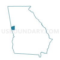
Outline

Summary
| Unique Area Identifier | 562991 |
| Name | 28505 - WEST POINT Voting District |
| County | Troup County |
| State | Georgia |
| Area (square miles) | 11.74 |
| Land Area (square miles) | 11.47 |
| Water Area (square miles) | 0.27 |
| % of Land Area | 97.67 |
| % of Water Area | 2.33 |
| Latitude of the Internal Point | 32.90273610 |
| Longtitude of the Internal Point | -85.15461960 |
Maps


Graphs
Select a template below for downloading or customizing gragh for 28505 - WEST POINT Voting District, Troup County, Georgia


Neighbors
Neighoring Voting District (by Name) Neighboring Voting District on the Map
- 145SK - SKINNER Voting District, Harris County, GA
- 28511 - LONG CANE Voting District, Troup County, GA
- 28513 - GRAY HILL Voting District, Troup County, GA
- Fredonia Voting District, Chambers County, AL
- Lakeview/Lanett/Huguley Rescue Voting District, Chambers County, AL
Top 10 Neighboring County Subdivision (by Population) Neighboring County Subdivision on the Map
- Valley CCD, Chambers County, AL (13,966)
- Lanett CCD, Chambers County, AL (9,961)
- West Point CCD, Troup County, GA (5,503)
- Pine Mountain CCD, Harris County, GA (5,167)
Top 10 Neighboring Place (by Population) Neighboring Place on the Map
Top 10 Neighboring Unified School District (by Population) Neighboring Unified School District on the Map
- Troup County School District, GA (67,044)
- Harris County School District, GA (32,024)
- Chambers County School District, AL (27,747)
- Lanett City School District, AL (6,468)
Top 10 Neighboring State Legislative District Lower Chamber (by Population) Neighboring State Legislative District Lower Chamber on the Map
- State House District 129, GA (53,120)
- State House District 38, AL (44,337)
- State House District 37, AL (43,958)
Top 10 Neighboring State Legislative District Upper Chamber (by Population) Neighboring State Legislative District Upper Chamber on the Map
Top 10 Neighboring 111th Congressional District (by Population) Neighboring 111th Congressional District on the Map
Top 10 Neighboring Census Tract (by Population) Neighboring Census Tract on the Map
- Census Tract 9610, Troup County, GA (5,503)
- Census Tract 1201.98, Harris County, GA (5,167)
- Census Tract 9545, Chambers County, AL (3,804)
- Census Tract 9539, Chambers County, AL (2,900)
- Census Tract 9544, Chambers County, AL (995)